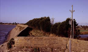
Wexford Harbour landscape before the 1840s
Early maps of Wexford Harbour, by Sir William Petty (1657) and others, show that there were a number of islands in existence, six in total with the largest being Begerin, Big Island and Korrugh (or Cora Island), and Breast Island. The first attempt at land reclamation was made in 1814 when two brothers, the Thomas brothers made plans to reclaim 800 acres of land on the south-eastern side of the harbour at a cost of £30,000.
By 1816 the Thomas brothers had succeeded in building a bank that kept the sea out but a high tide caused the bank to crash, thus halting the reclamation works.
Old maps of Wexford Harbour
Map of Wexford Harbour
Speed (1612)
Map of Wexford Harbour
Petty (1657)
Map of Wexford Harbour
Lewis (1837)
The Reclamation work
In 1840 a second, more ambitious plan, was put into action; the aim now was to complete reclamation of both the north and south wings of the harbour. A new interest in the project came after an Act was passed in the British parliament in the years preceding 1840 which provided government aid for the reclamation of waste land in Ireland.
It was a syndicate from Scotland that undertook the work, this was an ambitious project which not only included Wexford Harbour, but other sites in south Wexford such as Ballyteige, Bannow and Lady’s Island, as well as Tramore and Dungarvan along the Waterford coast.
The syndicate employed an engineer by the name of Vetch to carry out a survey of the proposed reclamation area. He proposed a North embankment enclosing 2,192 acres, and a south embankment enclosing 3,341 acres, part of which used the remains of the Thomas Brothers 1816 embankment.
The local landowners, ship owners and merchants of Wexford had their reservations about the project. Their biggest fear was that too much control of the harbour would be handed over to a group of strangers, whose ideas may differ from local interests. The harbour men organised their own engineers to survey the area, their reports suggested that the proposed works may cause the harbour to silt up, thus causing difficulties to shipping. The local people organised a petition to parliament against the project, and questions were raised as to who actually owned the mudflats, whether they belonged to the Crown or to the owners of the land that adjoined them.
The opposition of the Wexford merchants must have daunted the Scottish syndicate, as they abandoned the project, the prospect of undertaking such works under hostility was not very inviting.
It was at this stage that a prominent Wexford family, the Redmonds, entered the project. John Edward Redmond, a young man with great wealth, who had already made great improvements to the town, took up the idea of reclaiming land on the north side of the harbour. Again the local merchants (The Wexford Harbour Commissioners) addressed a letter to the Parliamentary Representative stating their opposition to the
proposed work.
John Redmond was not to be put off, and despite opposition, the Act of Parliament was obtained allowing for the project to progress.
The operations began in 1847, the worst year of the Great Potato Famine, when providing employment for labourers was of the utmost importance. Men came from all over the county armed with sprongs, shovels
and picks .
The artificial bank on the North Slob was built as a continuation from the natural bank and clay was brought from nearby heights and from one of the small islands for the construction. The banks were eight feet (2.5 metres) wide at the top and enclosed more than 2,400 acres. By 1849 the North Slob project had been completed, conquering what had appeared to be insurmountable natural impediments along the way.
In 1850 and 1851 the land was ploughed and prepared for cultivation. The area was drained by canals and drains and pumps were also built to pump out the water.
For more information on the history of the North Slobs, see ‘High Skies-Low Lands; an Anthology of Wexford Slobs and Harbour’ edited by David Rowe and Christopher J. Wilson (1996).
The information here was taken from ‘The History of Land Reclamation in Wexford Harbour’ by Nicholas Furlong in the forementioned book.
Today
 For about 100 years much of the Slob lands provided rough summer grazing for livestock, although parts were cultivated for cereals and root crops. Since the 1960s drainage has been improved and farming has been intensified. Nowadays most of the lands are sown with high quality grasses and winter/spring cereals, although on occasions a variety of other crops have been planted.
With the exception of the extensive main channels and their edges, where water plants and reed beds flourish, the Slobs are completely agricultural and reminiscent of Dutch polders.


